
Environmental screening made simple
FEMA flood zones and wetlands by address—clear, fast, and decision-ready environmental insights for site selection.
Trusted for environmental due diligence
Environmental screening that delivers results
The old way
- Hours researching FEMA maps and wetlands databases
- Confusing technical jargon and unclear risk levels
- Missing environmental flags until late in diligence
- Expensive surprises during permitting
With reSpots Environmental
- Instant FEMA and wetlands screening by address
- Plain-language summaries with clear next steps
- Early-stage risk identification and flagging
- Exportable reports for stakeholder communication
Complete environmental screening in minutes
FEMA Flood Risk
Visualize flood zones (AE, X, VE), understand floodplain exposure, and identify Base Flood Elevation context.
- Zone identification (AE, X, VE)
- Floodplain presence mapping
- Base Flood Elevation context
- Effective vs preliminary zones
Wetlands Screening
Surface likely wetlands presence using authoritative sources (NWI) to flag permitting risk early.
- NWI wetlands identification
- Buffer zone awareness
- Permitting risk flags
- Early-stage screening
Decision Support
Exportable summaries for teams, lenders, insurers, and municipal conversations.
- Plain-language summaries
- Exportable reports
- Team collaboration
- Stakeholder communication
Built for your workflow
Developers
Early-stage feasibility checks and entitlement planning. Spot areas requiring delineation or mitigation ahead of submittals.
Lenders & Insurers
Risk assessment and premium context. Capture environmental flags affecting credit decisions and insurance quotes.
Brokers
Faster qualification and disclosure. Provide clients with environmental clarity during site selection.
Site Prioritization
Screen multiple candidate sites and focus resources where environmental risk is lowest.
See environmental risk at a glance
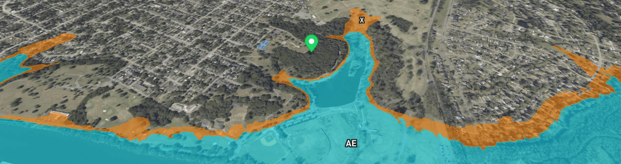
FEMA Flood Zones
Clear zone identification (AE, X, VE) with floodplain boundaries and Base Flood Elevation context.

Wetlands Screening
NWI wetlands identification with buffer zones and permitting risk assessment.
Trusted by industry professionals
Environmental screening in 30 seconds vs hours of research. Game-changer for early feasibility.
Clear FEMA zone identification help to avoid a site with major flood risk. Saving months of wasted effort.
Wetlands flags let you factor permitting risk into your pro forma from day one.
How it works
- 1Enter address
Search any property by address. System automatically identifies location and loads environmental layers.
- 2Review overlays
See FEMA flood zones and wetlands overlays with clear visual indicators and risk context.
- 3Get summary
Receive plain-language findings with next steps for due diligence, permitting, and stakeholder communication.
Frequently asked questions
What does Environmental include?
FEMA flood zone exposure (e.g., AE, X, VE) and wetlands screening using authoritative sources for early-stage due diligence.
Is this a replacement for surveys or delineations?
No. It's a high-signal screening tool to identify potential risk and inform next steps like surveys or formal delineations.
Who is it for?
Developers, lenders, insurers, and brokers needing fast environmental risk checks during site selection and underwriting.
How accurate is the screening?
We use authoritative sources like FEMA flood maps and NWI wetlands data. Results provide directional guidance that should be confirmed with certified professionals.
Can I export the results?
Yes. Generate exportable summaries for internal teams, lenders, insurers, and municipal pre-application conversations.
What areas are covered?
Environmental screening is available nationwide where FEMA flood data and NWI wetlands data are available.
How fast is the screening?
From address search to environmental summary in under 60 seconds. See flood zones and wetlands context instantly.
Do you show Base Flood Elevation?
Yes, where available. BFE context helps understand flood risk severity and potential mitigation requirements.
Know your environmental risk in minutes
Stop guessing about flood zones and wetlands. Get instant environmental screening that speeds up diligence and reduces risk.
Disclaimer: Environmental is a screening tool and does not replace formal surveys, delineations, or regulatory determinations. Data sources may be updated periodically; confirm with local authorities and certified professionals.